Mapping shellfish reefs in southeast Queensland for protection, management and restoration
- Posted by César Herrera
- On January 28, 2025
Download the Shellfish Reef Fact Sheet.
New collaborative project between Department of the Environment, Tourism, Science and Innovation (DETSI) and GLOW will map shellfish reef in southeast Queensland.
Significant shellfish reef declines have occurred in southeast Queensland. Knowledge of the distribution and condition of these ecosystems in this region is currently limited, but essential for informing appropriate conservation measures. This project will provide critical information on the historical and current distributions of shellfish reefs and their present condition in southeast Queensland in order to facilitate their protection and management.
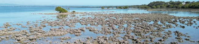
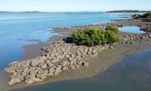
Rock oyster reefs on rocky substrate Sandstone Point. Photo Marina Richardson
Why is this project needed?
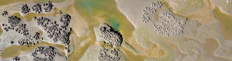
Shellfish reefs are intertidal or subtidal wetland habitats created by dense aggregations of oysters and/or mussels. These habitats provide important ecosystem services, such as shoreline
stabilization, water filtration, nutrient assimilation, and habitat for marine life, including recreationally and commercially harvested species. Shellfish reefs were once abundant in the Great Sandy Strait and Moreton Bay but are now considered to be functionally extinct due to a range of factors including over-harvesting, parasites, disease and sedimentation. Knowledge of the current extent and condition of remnant reefs in southeast Queensland is lacking, but essential to inform their future management, conservation and restoration.
Leaf oyster reef on muddy sediment, Maaroom. Photo Maria Zann.
What is the project aim?
The project aims to map the historical and current distribution of intertidal and subtidal shellfish reefs south of Bustard Head in southeast Queensland, including Great Sandy and Moreton Bay marine parks, and to evaluate their present condition. Areas located with high numbers of shellfish that may not meet criteria to be defined as shellfish reefs will also be included in mapping. Current shellfish reefs will be mapped using a three-part strategy:
- Satellite imagery
- Consultation with local stakeholders including Government, industry, restoration practitioners and Traditional Owners
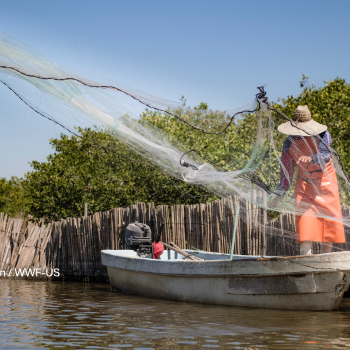
- Collaboration with local fishers.
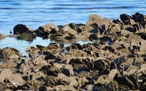
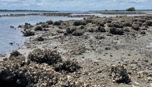
Rock oyster reefs on muddy sediment, Turkey Beach. Photo Marina Richardson.
The location of historical shellfish reefs will be informed by existing literature, historical fisheries records, and archived newspaper articles (National Library of Australia Trove database). To evaluate reef condition, several large reefs will be characterised. Collected data will include site characteristics, reef area, live shellfish densities, reef-building species identification, and quantifying associated invertebrate communities.
These assessments will be used to select a subset of easy-to-use measures for rapid yet robust assessments at future sites, and to refine parameters for shellfish reef definitions. Intertidal shellfish reefs will be mapped and modelled using an RTK drone to extract high resolution spatial attributes. This attribute data will determine the nature and extent of shellfish ecosystems and their typologies through the biological and physical factors that characterise them under the Queensland Intertidal and Subtidal Ecosystem Classification Scheme. This project aligns with approaches of the Queensland Government Aquatic Ecosystem Rehabilitation Framework and Whole-of-System, Values-based management framework to identify directions forward to restore shellfish reef ecosystem services and values.
This project builds on the current National Environmental Science Program (NESP) project led by Griffith University that will map and characterise tropical Australian shellfish reefs. Project completion in southeast Queensland is expected by June 2025. The information gained from this project together with shellfish reef mapping across tropical Australia will collectively provide a robust basis for shellfish reef management in Queensland, including within Marine Parks, Ramsar sites and World Heritage Areas, help to establish conservation needs, and inform threatened habitat listings under the EPBC Act.
Rock oyster reefs on shell and mud, Pumicestone Passage. Photo Marina Richardson.
Who is involved?
This project is led by the Global Wetlands Project at Griffith University in collaboration with the University of the Sunshine Coast and funded by the Queensland Governments Department of Environment, Tourism, Science and Innovation.
Further information
For more information about the project, contact Dr. Marina Richardson at marina.richardson@griffith.edu.au.
0 Comments